A simple Mathematical Process.
GPS, as intricate as it may look, works based on a simple Mathematical Process named 3-dimensional Trilateration. To fully understand 3 dimensional Trilateration, it is important to have a basic knowledge of its prerequisite, namely 2-D Trilateration.
2-D Trilateration
Its simply the use of circles in order to locate an object. Here’s an example(figures not to scale):
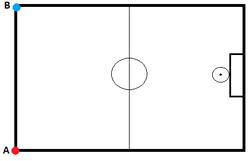
You are told that there is an imaginary Basketball on the court. You need to find the exact location of that
Ball based on the information provided.
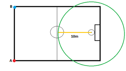
- 1st clue: ball is located 10m from
the hoop.
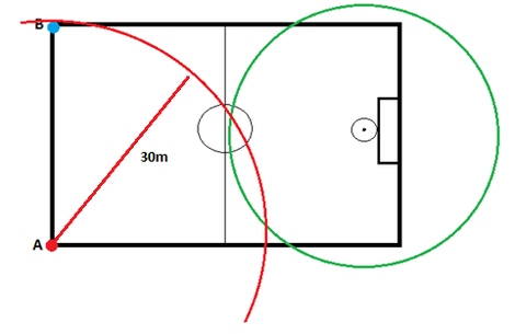
- 2nd clue: ball located 30m from point
A
The ball can now be located at two different points, namely the 2 points
where the green and red circle(rest of circle purposely cut off) overlap.
- A third circle is thus needed to know the exact
location of the ball. You are told that the ball is 25 m from point B.

The intersection of these 3
circles corresponds to the exact location of the basketball. In other words, it’s
the only location where the ball would be simultaneously 10m from the hoop, 30m
from point A and 25 m from point B.
Through the use of 3 circles, or , in other words by using 2-D Trilateration, we found the exact location of our imaginary basketball.
--------------------------------------------------------------------------------------------------------------------------------------------------
Through the use of 3 circles, or , in other words by using 2-D Trilateration, we found the exact location of our imaginary basketball.
--------------------------------------------------------------------------------------------------------------------------------------------------
3-D Trilateration
3 dimensional Trilateration works the same way, except that the circles are replaced by spheres. Here’s how 3-D Trilateration is used in the Global Positioning System to locate the exact position of an object.
As you read earlier, the GPS receiver receives and interpret radio waves emitted by at least 4 Satellites. Similarly to 2-D Trilateration, the intersection between those spheres will determine the exact location of the GPS receiver.
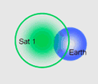
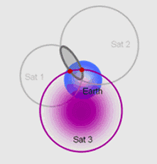
The GPS receiver receives signal from 1st
Satellite, calculates the distance between itself and the satellite. Lets say
the receiver is 20 000 km from the satellite. This means that the receiver
could be at any point in any direction on the surface of the green sphere with
a radius of 20 000 km.
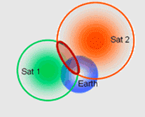
The receiver captures another signal from Satellite 2. After
calculating the distance, we notice that the two sphere’s overlap to form a
perfect circle. The receiver could be anywhere on the edge of that circle.
The receiver captures radio waves from a third
Satellite. We notice that the 3 spheres overlap at 2 points. These are the 2
possible locations of the GPS receiver.
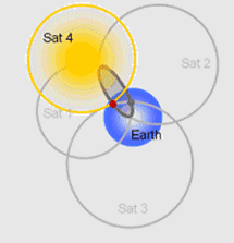
A fourth signal received from a fourth
Satellite determines the exact location of the GPS receiver. This location
corresponds to the sole point of overlap of the 4 spheres.
As you just saw, a simple mathematical process is what makes possible this amazing technology.
As you just saw, a simple mathematical process is what makes possible this amazing technology.
